

Eight Interesting Aspects: Narragansett Bay and the Invention of Rhode Island - Andrew Middleton
0 of 0
Click here to enter exhibit
1
13
13
Eight Interesting Aspects: Narragansett Bay and the Invention of Rhode Island - Andrew Middleton
Exhibit Stories:
Eight Interesting Aspects: Narragansett Bay and the Invention of Rhode Island - Andrew Middleton
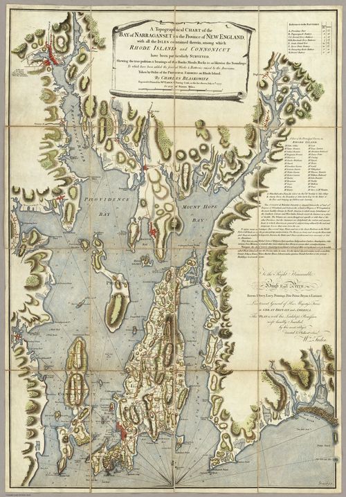
Hidden in this British invasion map is the history of a state's founding identity.

As of August 2024, Andrew Middleton has owned the Map Center, the oldest map store on the East Coast, for nine months, on his quest to introduce cartography enthusiasts to a new generation of maps.
You can visit Andrew at the Map Center at 545 Pawtucket Ave, Pawtucket, Rhode Island and at https://www.mapcenter.com/.

- Andrew Middleton - DOT story - Eight Interesting Aspects - Narragansett Bay and the Invention of Rhode Island - 8/8/24
- Andrew Middleton - DOT story - Eight Interesting Aspects - The Myths of Rhode Island - 8/8/24
Tags: Andrew Middleton The Map Center
Categories:
What Topic
History
Interesting Aspects
What Type
Maps
Where
Rhode Island
When
C18
Y1777
Who Creator
Charles Blaskowitz
Who Collector
Andrew Gu
Andrew Middleton
Curators:
Andrew Gu(@amg11),
tomcurator(@tomcurator),
Andrew Middleton(@andrew_middleton).
Start screensaver
Please Choose seconds per image
Start Exhibit Story at specific step
Start Run of Show at specific story
Loop Exhibit Story
Choose duration for A step
Choose duration for B step
Choose zoom-in animation time
Choose zoom-out animation time
Finalise exhibit story
| Step & Preview | Auto-play | Pan | Line | No zoom-out | Actions |
|---|
Place a DOT on the image