The discovery of gold in the western foothills of the Sierra Nevada led to a series of dramatic political, demographic, and environmental changes. The chase for gold also contributed to a deep understanding of the region’s geology, uncovered by miners as they combed the landscape in search of riches. The richest gold ore was found in the Mother Lode, a narrow band in the western foothills stretching from Georgetown in the north to Oakhurst in the South.
2
Christopher Hughes
(@chughes)
Aug 11 2025
0.4
0.35
i37871
James Marshall discovered several gold nuggets in the millrace of a sawmill he was building along the South Fork of the American River. The gold, heavier and more durable than river gravel, was nestled in a bedrock crevice. It was a classic placer deposit.According to the USGS “Placer deposits result from weathering and release of gold from lode deposits, transportation of the gold, and concentration of the gold dominantly in stream gravels."
This sketch, drawn by James Marshall in 1850, shows the area around the sawmill in early 1848. The mill, built to provide lumber for John Sutter’s fort near Sacramento, was sited in a valley surrounded by pine-covered hills.
3
Christopher Hughes
(@chughes)
Aug 11 2025
0.38
0.4
i3787
It didn’t take long for miners to arrive, and maps of the mines to appear. Positions of the Upper and Lower Gold Mines on the South Fork of the American River, California illustrates mines stretching at least 25 miles along the America River in the summer of 1948. At the time “there were about 4,000 persons engaged in collecting gold.” The map was included alongside president Polk’s 1848 State of the Union Address, a speech which triggered the gold rush.
4
Christopher Hughes
(@chughes)
Aug 11 2025
0.45
0.48
i37874
By 1950, miners had swarmed to California, and scoured the Sierra Foothills’ streams searching for gold. Their quest expanded from streambeds to riverside gravel bars, and even to dry deposits on the hillsides above. The Map of the mining district of California, drafted in 1850 by William A, Jackson, shows the locations of placer mines and “dry diggings”, alongside Native American villages and prominent topography.
5
Christopher Hughes
(@chughes)
Aug 11 2025
0.32
0.39
i37875
Miners rapidly depleted the easily accessible placer deposits, and soon began to search for the source rock. The process was conceptually simple — move upstream and keep panning for gold until it runs out. Then examine the hillside above for outcroppings of quartz. While that’s easier said than done, California hard rock mining exploded in the 1850s.
Opened in 1851, the Ophir Mine was one of the earliest underground mines in California. It was located in Mariposa County near the southern end of the Mother Lode. This detailed map of the Ophir Mine shows outcroppings of ore bodies, the locations and depths of mine shafts, and the position of nearby mining claims.
6
Christopher Hughes
(@chughes)
Aug 11 2025
0.51
0.42
i37876
Much of this activity was focused along the Mother Lode Gold Belt. A geological map in 1896 shows mining claims in the belt, which correspond closely with a formation of “black slate” studded with gold-rich quartz veins. This formation aligns with the Melones Fault Zone, a geologic region where a volcanic island arc (similar to modern Indonesia or Japan) collided with ancestral California. Tectonic forces sutured the island arc onto continental North America.
The map is as intriguing for its innovative layout as it is for the geology it records.
7
Christopher Hughes
(@chughes)
Aug 11 2025
0.24
0.31
i3787
Underground mines have a complex, three-dimensional structure, which makes them particularly hard to map. This spectacular block diagram from a USGS brochure shows host rock, gold-rich veins, and mine shafts of the Empire Mine in Grass Valley, California.
8
Christopher Hughes
(@chughes)
Aug 11 2025
0.3
0.28
i3787
Another type of underground mining was drift mining, in which miners tunneled into buried river gravels deposited millions of years earlier. These mines were located along ancestral river channels filled with gold-rich blue gravel. The California State Mining Bureau assembled this map of the Iowa Hill Mining District in ~1890. It highlights some of the most product drift mines.
9
Christopher Hughes
(@chughes)
Aug 11 2025
0.21
0.25
i37879
An alternative method to reaching buried river gravels was hydraulic mining. Instead of tunneling underground, Miners used streams of water to erode away hillsides to reach the gold-rich gravel just above bedrock. Often more economical than drift mining it had two significant downsides: it required copious amounts of water and exacted tremendous ecological damage. So much so that the California Supreme Court banned the practice in 1884. This satellite view collected on August 6, 2025, shows the scars left behind by the Malakoff (right) and North Columbia (left) Diggins. Malakoff Diggins, the state’s largest hydraulic mine, is now a state park.
10
Christopher Hughes
(@chughes)
Aug 11 2025
0.17
0.41
i37880
While tectonic forces lifted the Sierras and helped concentrate gold into spectacular deposits, the relentless process of erosion dismantled the mountains almost as quickly as they rose. Some of the eroded gold was left behind, but even more was carried to California’s Central Valley. Giant dredges worked these deposits, simultaneously digging vast quantities of gravel, separating the gold, and leaving behind piles of tailings.
This modern USGS topographic map shows the remnants of the Hammonton dredge field. A series of long, low hills separated by stagnant ponds stretched out along the lower reaches of the Yuba River. The tailings, cleansed of gold, are now a source of aggregate, sand, and gravel.
11
Christopher Hughes
(@chughes)
Aug 11 2025
0.45
0.35
i37881
After the ban on hydraulic mining and exhaustion of riverbed placer deposits dredging, drift, and hard rock operations continued through the first half of the 20th Century. In late 1942 President Roosevelt closed American gold mines to focus production on minerals essential to the war effort. After World War II few mines were able to re-open, and most had closed permanently by the 1950s and ’60s. More than a century of mining had left behind an extensive industrial landscape, a series of gold-rush towns strung along the mother lode outcrops, and a complex environmental legacy. A handful of mines remain in operation, with more proposed every time the price of gold spikes.
This block diagram by the USGS shows the topography of the western slopes of the Sierra Nevada and the locations of thousands of known mines. Also of interest is the ranking of lifetime production, with the unglamorous dredging operations along the Yuba River producing about 460 million dollars worth of gold compared to 130 million from the Empire Mine.
12
Christopher Hughes
(@chughes)
Aug 11 2025
0.02
0.03
Robert Simmon is a cartographer and science communicator who specializes in visualizing satellite data. He has decades of experience working with remote sensing experts and entrepreneurs, helping share their research and products with the public. Along the way he’s designed some of the most widely viewed imagery of our home planet.
His work has appeared in newspapers, magazines, and web sites; including the front page of the New York Times and the cover of National Geographic. He’s also known for creating the first global view of the Earth at Night, crafting the Blue Marble featured on the original Apple iPhone, and writing about best practices for scientific visualization.
1
2
3
4
5
6
7
8
9
10
11
12
Exhibit ID:715
0
0
12
1
11
Interesting Aspects - California Gold Rush - Robert Simmon
Exhibit Stories:
Interesting Aspects - California Gold Rush - Robert Simmon
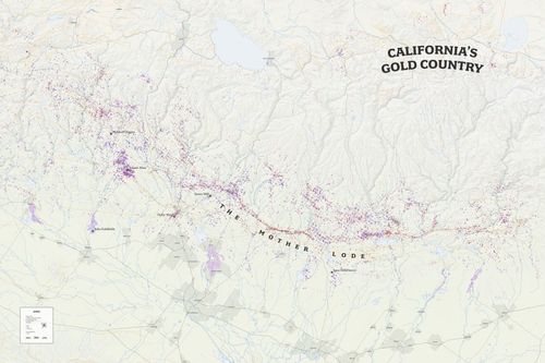
A detailed original map of the California Gold Rush created by renowned cartographer Robert Simmon.