Islamo-Christian Cartographic Frontiers: Views from Medieval Islamic Maps of the Mediterranean
Step 0 of 0
1

2

3

4

5

6

12th-century Islamic Map of the Mediterranean Belonging to Frederick II
Click on the the Show Dots button (image below) to find a guided tour through this map by Professor Karen Pinto.

After that, click on the Dot Story entitled "Ten Intriguing Aspects by Karen Pinto."
Academic Image Description:
This medieval Islamic representation of the Mediterranean is classified as a late 12th century work of medieval Sicilian provenance. It is from an Arabic geographical manuscript titled Kitab al-masalik wa-al-mamalik ascribed to Abu ‘Abbas Ahmad ibn Ibrahim al-Istakhri al-Farisi [sic]. The colophon of the manuscript provides a firm date of Rabi‘ I 589 A.H. (April 1193 C.E.) This manuscript is housed in Leiden at the Bibliotheek der Rijkuniversiteit, Cod. Or. 3101. The map is located on folio 33a.
This map stands out as one of the best examples of a particular iconographic form that emerged as the hallmark of medieval Islamic representations of the Mediterranean. It is a highly stylized geometric form with a bulbous base and a narrow neck that portrays both sides of the Mediterranean as perfect mirror images of each other. In addition, the three large circles in the center, markers for the islands of Cyprus, Crete, and Sicily, capped off by a large triangle adorned with inverted crescents, form a prominent vertical axis in the image. The map-maker is suggesting that these islands are crucial stepping stones of the Mediterranean; conversely s/he may have been trying to use them to indicate a major division between the northern and southern portions of the sea with the islands serving as the ultimate barrier between the Christian and Muslim sides. The strange, triangular, mythical island, which heads up the other known islands, is enigmatically labeled Jabal al-Qilal (Mountain of Qilal). This island appears to act as a cap to the Mediterranean. Its inverted crescent markings give the impression of a formidable barrier beyond which the sailor should not venture. It is tempting to read into this mythical island a muslim symbol for the Pillars of Hercules – the Pillars beyond which it was said only death and danger lay.
The horizontal axis with the large semi-circular gulf containing the islands of Dumyat and Tinnis, on the left-hand side of the image, versus the rectangular inlet of the Bosphorus, on the opposite side, unbalances the symmetry of the image. It is as if the cartographer is deliberately disrupting the rigid central vertical axis of the image to suggest contrarily that the northern and southern flanks of the Mediterranean are in fact not perfect mirror images of each other. This opens up the reading of the map to suggest that differences unbalance the image or that the differences actually provide an alternate point of connectivity across the Mediterranean. The interpretation of the latter is dependent upon the interpretation of the central vertical axis. If the central vertical axis serves to provide a unifying seam across the sea then the horizontal axis serves to disrupt it. If, on the other hand, the central vertical axis is meant to be read as a rigid boundary dividing the sea into two equal halves then the horizontal axis could be read as either an unbalancing of the sea to the Muslim side or as a node of communication between the primary Muslim and Christian powers of the region: Byzantium and Egypt.
The gaze of the cartographer/viewer moves along the central vertical island-axis: from the heart of the Islamic world in the East at the base of the map, looking out towards the West, to the top of the map and the mouth of the Mediterranean, which opens out into the Encircling Ocean.
Leiden Mediterranean Map - Line Drawing Translation
Leiden Mediterranean Map - Translated with a Line Drawing
Line-drawing translation of KMMS Mediterranean map prepared by Karen Pinto to make it easier to understand the layout of places around the classical Medieval Islamic Map of the Mediterranean. I have resolved the identification of most of the places on the map in some cases by going to ground to identify places that could not be determined by aerial maps and scholarly texts alone. This was facilitated by a 5 year teaching stint at the American University of Beirut that made it possible for me to make field trips to previously unidentified sites in the area. The 2006 war—which we experienced and ran away from in shock—facilitated further identification of sites in the Cilician plains of Anatolia due to a forced evacuation that I put to good medieval map use.
The only place that still remains unidentified is a place that reads Ulas in Arabic on the map that could be a reference to Ayas in southern Anatolia but could perhaps be an abbreviation of the famed Metropolis of Roman yore. This is likely to be a mystery that will never be fully resolved. It is, however, fascinating to see what an interest the mapmakers took in South-eastern Anatolia—i.e. the famous medieval battleground of the Cilician planes, which was an actively contested space of the frontier.
Leiden Mediterranean Map - Modern Equivalent
Map labeled by Andrew Gu, Pixeum 2024 Summer Intern, under the direction of Karen Pinto.
Laying out the places on a modern map reveals the surprising result that the distribution of the places around the Mediterranean are not evenly spaced. Quite the contrary! The places are instead clustered around the two major frontiers that dominated this sea in the Islamic imagination: Namely in the eastern and westernmost ends of the sea where the major frontiers between the Muslim and Christian worlds lay. Called thughur—a word in Arabic that derives from the bared teeth of dogs—the thughur al-Shamiyya (the frontier of Syria and Byzantium) and the thughur of al-Andalus (the frontier of Muslim Spain) define the Muslim depiction of the Mediterranean and, nothing makes this clearer, than laying the places from the medieval map onto a modern one. For this terrific work of depiction I am grateful to Pixeum’s amazing intern from this past summer, Andrew Gu.
13th Century Mamluk Rendition of KMMS Mediterranean Map (Photo: Karen Pinto)
From a manuscript at Topkapı Saray Museum in Istanbul that is definitively dated via it’s colophon to 684 AH /1285 CE is a rendition of the Mediterranean map made in Mamluk Egypt. We know this because of the signature of its copyist with the last name (nisba) of al-Miṣrī (the Egyptian) which tells ‘us that TKS A3348 was copied in Egypt during the rule of the Baḥrī Mamluks, specifically the Mamluk Sultan known as Sayf al-Dīn (r. 1270-1290).
The classical bulbous iconographic form discussed in detail in the dot story on the twelfth century Siculo-Norman map at the outset of this presentation is maintained along with the role that the three islands of Sicily, Crete, and Cyprus play in dividing up the Mediterranean. This time around the sea appears to be a bit plumper and rounder and the mythical island at the mouth of the Mediterranean veers from it earlier central location at the mouth of Mediterranean to closer to the North African flank.
The illumination of this Mamluk version is, however, noticeably different and visually much more dramatic than the Siculo-Norman rendition. In particular, the sea is decorated with a detailed dramatic design of scalloped waves and the site markers have morphed from dots into what looks like the turrets of citadels dotting the perimeter of the sea. In this way, the Mamluks, known in particular for their military prowess and success in battle even against the indomitable Mongols, have turned their rendition of the KMMS map of the Mediterranean into a map of war and conflict.
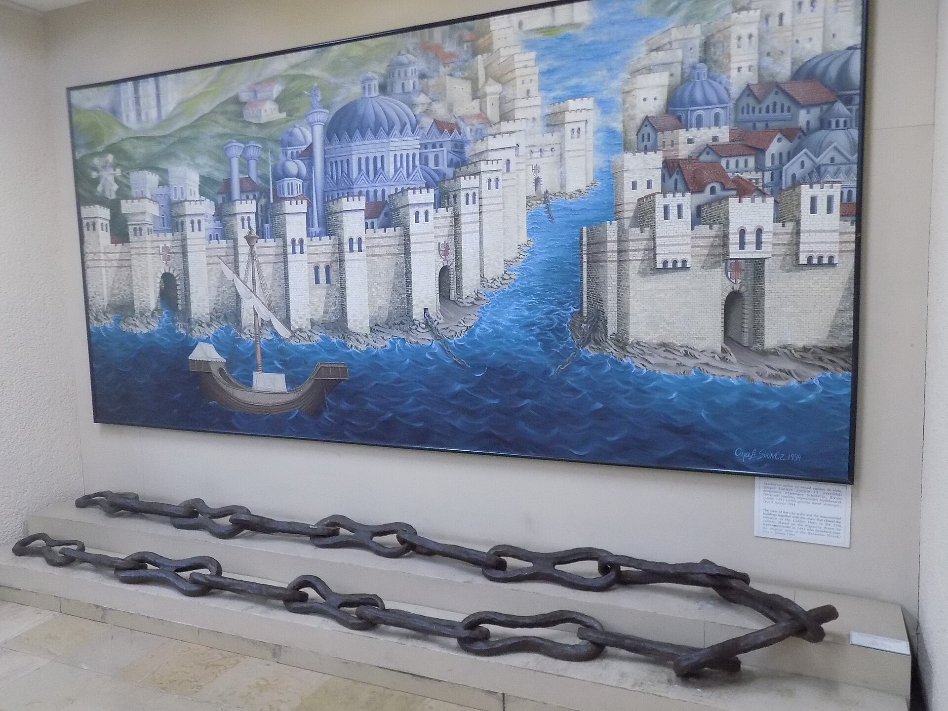
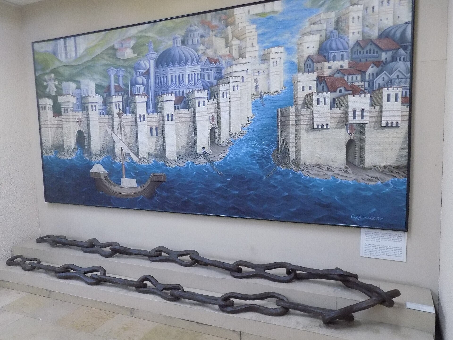
To our great serendipitous surprise and historical delight, the illuminator of this map even decided to include on their version of the Mediterranean the famous chain that the Byzantines used to guard the mouth of the Mediterranean. Today this chain is a historical relic proudly displayed at the naval musuem in Istanbul!
To the best of our knowledge, this is the only extant visual depiction of the chain guarding the mouth of the Mediterranean in Islamic illumination records that caused many an Islamic conqueror to fall back until the brilliant Ottoman emperor and famed conqueror Mehmet II came up with a solution to slide the boats he used to attack the city across that Asian side (known as Galata) of the Bosphorus on greased logs! Thus, in 1453, barely 21-year old Mehmet II was able to complete the 800 year long Muslim desideratum to conquer Constantinople and take what had been dubbed colloquially by the Turks as the Kızıl Elma—i.e. Red Apple.

Persian Timurid Mediterranean Map (Photo: Karen Pinto)
This late 14th/ early 15th Century Timurid Mediterranean Map labeled in Persian presents a refreshing take on the classical KMMS depiction of the Mediterranean. The sea is still iconographically bulbous round and easily recognizable as the classical KMMS form attributed to the Mediterranean but the rivers separating the Islamic and Byzantine lands are significantly elongated and command the attention of the viewer at the expense of the sea. In a nod to the time period of this copy, deer with roses in their mouths frolic in Anatolia indicating that that frontier is no longer one of anxiety. This is in keeping with the historical period when this version was made. Turkic groups from Central Asia had penetrated Anatolia and were slowly taking control away from the Byzantines as their final defeat at the hands of the Ottomans in 1453 drew close. On the European front, the boxes representing the cordoned off Christian territories have grown in size as the Iberian peninsula has shrunk indicative of the successful Christian Reconquista of Andalus from Muslim rulers.
The mythical Jabal al-Qilal mountain is now adorned with a peacock instead of scary symbols suggestion a peaceful rapprochment of sorts across the Mediterranean, especially the entrance into it.
Place a DOT on the image


