.Mapmaking in Islamic Societies
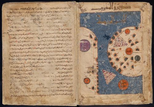
Hundreds of maps survive mostly in manuscripts drawn and colored by unknown people over a millennium in numerous different societies that were ruled mostly by men but also occasionally by women adhering to different Islamic denominations. The manuscripts with maps are often undated and provide rarely information about the place of production. How then can we know when and where or by what kind of person they were made? Colors, styles of script, also called calligraphy, the type of paper and occasionally of card board, traces of instruments or lack of them, content features of the maps, and notes on cover or end pages, at the margins, or on other parts of the manuscript and the langue/s used in the manuscript can help us identifying at least the period, region, culture or disciplinary context of the people who drew the maps – scribes, painters and other craftsmen, scholars, captains, soldiers, court historians and possibly other professionals and amateurs.
This exhibit is a brief introduction into some of the main domains where maps were used as illustrations of texts, as carriers of independent information, as educational tools, or as witnesses of cross-cultural contacts and interests.
Generally, four classes of maps are recognized:
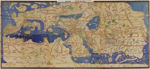
1. maps derived in some way or the other from Ptolemy's Geography
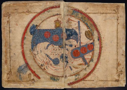
2. maps connected somehow with pre-Islamic Iranian political geography
3. maps reflecting connections with cartographic developments in European Christian cultures
4. narrative maps.
This classification is admittedly too narrow to do justice to the many different specimens that survive in many libraries and museums across the globe. It somehow also hides what is in my view the main, unifying feature of almost all maps from Islamic societies that I have seen: the multiplicity of their cultural features. The only class that does not bring together elements from at least two other classes is number 4.
In addition to the maps that can be included into one of the four classes there are exceptional specimens which differ from any of the standards represented by them.
In this introduction, we show a few examples of each of the four classes and of the exceptions.
Based on the work of Sonja Brentjes.
Academia.edu
Tags: