Various European and Global Maps

0 of 0

0 of 0

Click here to enter exhibit

Step 0 of 0


Step 0 of 0


1

E226 - War Map
E226 - War Map

2

E226 - Map of Geneva Omega Longines  Advertisement Broadside. 1
E226 - Map of Geneva Omega Longines Advertisement Broadside. 1

3

E226 - Map of Geneva Omega Longines  Advertisement Broadside.2
E226 - Map of Geneva Omega Longines Advertisement Broadside.2

4

E226 - Map of Geneva Omega Longines  Advertisement Broadside.3
E226 - Map of Geneva Omega Longines Advertisement Broadside.3

5

E226 - Map of Geneva Omega Longines  Advertisement Broadside. 4
E226 - Map of Geneva Omega Longines Advertisement Broadside. 4

6

E226 - Various Europena - i12907-12908-12909-12910-12911-12912

7

E226 - Campus inter Bohum et Borystenem - 1635

8

Carta Marina
Carta Marina

9

Carta Marina LOC
Carta Marina LOC

10

1933 Keizo Shimada Japanese Manga Pictorial Map of the World

11

Japanese World Map with Stereotypes - 1932 

12

Ulm Ptolemy - 1482
Ulm Ptolemy - 1482
E226 - War Map
Image 1 of 12 | e226 | i5612 | 8860x6302px
E226 - War Map

ct

0
E226 - Map of Geneva Omega Longines Advertisement Broadside. 1
Image 2 of 12 | e226 | i5613 | 7632x10643px
E226 - Map of Geneva Omega Longines Advertisement Broadside. 1

ct

0
E226 - Map of Geneva Omega Longines Advertisement Broadside.2
Image 3 of 12 | e226 | i5614 | 7615x10676px
E226 - Map of Geneva Omega Longines Advertisement Broadside.2

ct

0
E226 - Map of Geneva Omega Longines Advertisement Broadside.3
Image 4 of 12 | e226 | i5615 | 8392x5996px
E226 - Map of Geneva Omega Longines Advertisement Broadside.3

ct

0
E226 - Map of Geneva Omega Longines Advertisement Broadside. 4
Image 5 of 12 | e226 | i5616 | 6274x7522px
E226 - Map of Geneva Omega Longines Advertisement Broadside. 4

ct

0

E226 - Various Europena - i12907-12908-12909-12910-12911-12912

Image 6 of 12 | e226 | i13235 | 14999x9655px
E226 - Various Europena - i12907-12908-12909-12910-12911-12912

World map by Pierre Desceliers. Source: Wikipedia

Chet van Duzer

The World for a King on Amazon.com

Chet Van Duzer is an American historian of cartography, specializing in medieval and Renaissance maps. He was born in 1966 and grew up in Northern California, and graduated from UC Berkeley. He is a member of the board of the Lazarus Project at the University of Rochester. Van Duzer has published extensively in the field of cartography, including his recent book "Henricus Martellus's World Map at Yale (c. 1491): Multispectral Imaging, Sources, and Influence". Source: perplexity.ai

0

E226 - Campus inter Bohum et Borystenem - 1635

Image 7 of 12 | e226 | i13895 | 8122x18084px
E226 - Campus inter Bohum et Borystenem - 1635

...

0

Carta Marina

Image 8 of 12 | e226 | i27898 | 5016x3715px
Carta Marina
0

Carta Marina LOC

Image 9 of 12 | e226 | i27899 | 9666x6505px
Carta Marina LOC
0

1933 Keizo Shimada Japanese Manga Pictorial Map of the World

Image 10 of 12 | e226 | i35988 | 4032x3024px
1933 Keizo Shimada Japanese Manga Pictorial Map of the World
0

Japanese World Map with Stereotypes - 1932 

Image 11 of 12 | e226 | i35987 | 5000x3616px
Japanese World Map with Stereotypes - 1932 
0

Ulm Ptolemy - 1482

Image 12 of 12 | e226 | i36508 | 27077x19358px
Ulm Ptolemy - 1482

Wikipedia | raremaps.com | perplexity

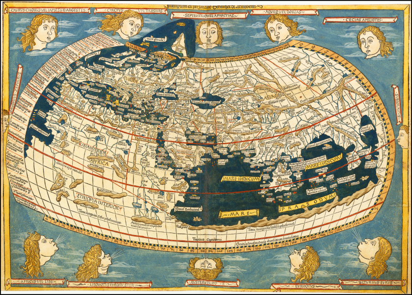
One of my favorite maps of all time, the story of this map is the story of Western civilization, which owes a debt to Islam. Ptolemy, in the 2nd century AD, knew and wrote about Europe, Africa and Asia, in a book called Geographia, which included the first system of longitude and latitude, as well as about 8,000 lat-long coordinates for cities. When the Roman Empire fell in the 5th century, Ptolemy’s book made its way to Bagdad and, during the Islamic Golden Age, from roughly 750 to 1250, this book was translated from Latin into Arabic. With the fall of Bagdad and the awakening of the Renaissance, this book made its way to Europe and, in 1482, Ptolemy’s book and this map were created and published in Ulm.


Write a 200-word summary of the map titled the Ulm Ptoley world map of 1482.

The Ulm Ptolemy world map of 1482 is a landmark in cartographic history, notable for being the first printed world map produced north of the Alps and the first to appear in color, with the seas rendered in a vibrant blue. Published by Lienhart Holle in Ulm, this map was based on the manuscript work of Donnus Nicolaus Germanus and engraved by Johannes Schnitzer of Armsheim, whose signature appears on the map—the earliest known example of a signed world map engraving16.

The map follows the Ptolemaic tradition but incorporates some contemporary updates, such as detailed depictions of Scandinavia and Greenland, reflecting the latest geographical knowledge of the time456. However, it omits Portuguese discoveries along the African coast and retains a closed Indian Ocean, linking Asia and Africa with a speculative southern continent12. Surrounding the map are twelve wind heads, each named, adding decorative and symbolic elements16.

Printed from woodblocks rather than copperplates, the map is visually distinctive, with bold, sturdy lines and rich coloring. The Ulm edition also introduced four new regional maps to the atlas, marking a significant evolution from earlier Italian editions. The 1482 Ulm Ptolemy remains highly prized for its artistic quality and historical significance456.

  1. https://www.raremaps.com/gallery/detail/14277/untitled-map-of-the-world-1482-ulm-ptolemy-world-map-ptolemy-holle
  2. https://www.raremaps.com/gallery/detail/8154/untitled-map-of-the-world-1486-ulm-ptolemy-world-map-ptolemy-holle
  3. https://www.raremaps.com/essay/5/the-ulm-ptolemy-of-1482-and-1486
  4. https://gallery.lib.umn.edu/exhibits/show/ptolemy-s-world/tour-of-maps/1482---ulm
  5. https://apps.lib.umn.edu/bell/map/PTO/TOUR/1482u.html
  6. https://www.christies.com/en/lot/lot-5780582
  7. https://collections.lib.uwm.edu/digital/collection/agdm/id/23096/
  8. https://demo.mediainfo.com/item/230
  9. https://www.cabinet.ox.ac.uk/ptolemy-world-map-1482-0
  10. https://www.geographicus.com/P/AntiqueMap/egypt-ptolemy-14

How did Geography by Ptolemy from classical times until the renaissance?

Ptolemy’s Geography (or Geographia) was a transformative work that shaped the understanding and representation of the world from classical antiquity through the Renaissance. Written around 150 AD, it introduced a systematic approach to mapping the world, using mathematical principles and a coordinate system of latitude and longitude based on a prime meridian at the "Fortunate Isles" (Canary Islands)15. Ptolemy’s work synthesized earlier geographic knowledge, notably refining the methods of Marinus of Tyre, and included detailed instructions for mapmaking, a gazetteer with coordinates for thousands of locations, and regional as well as world maps15.

After flourishing in the Roman and Byzantine worlds, Geography faded in Western Europe during the early Middle Ages, as religiously symbolic maps (like T-O maps) dominated5. However, the text was preserved and expanded upon by Islamic scholars, who translated and commented on it, keeping its scientific legacy alive5. The Renaissance saw a revival: Byzantine scholars reintroduced the text to Western Europe, leading to a Latin translation in 1406 by Jacopo d’Angelo15. Printed editions with reconstructed maps appeared from 1477 onward, revolutionizing European cartography by emphasizing empirical observation and mathematical accuracy over medieval symbolism145. Ptolemy’s methods influenced explorers, mapmakers, and the broader development of geographic science well into the modern era35.

  1. https://en.wikipedia.org/wiki/Geography_(Ptolemy)
  2. https://digitalmapsoftheancientworld.com/ancient-maps/ptolemys-map/
  3. https://press.uchicago.edu/ucp/books/book/distributed/P/bo56698759.html
  4. https://www.folger.edu/explore/collection-highlights/ptolemy-edition-of-1513/
  5. https://www.mixplaces.com/ptolemys-geography
  6. https://www.thoughtco.com/ptolemy-biography-1435025
  7. https://www.britannica.com/biography/Ptolemy
  8. https://library.fiveable.me/key-terms/hs-california-history/ptolemys-geography
  9. https://www.nypl.org/events/exhibitions/galleries/explorations/item/5384
  10. https://sterncenter.library.jhu.edu/early-book-collections/ptolemys-geography-in-the-renaissance/

[ 2025-06-01 18:46:28 ]

1
E226 - War Map

ct

Image 1 of 12
e226
i5612
8860x6302px
E226 - Map of Geneva Omega Longines Advertisement Broadside. 1

ct

Image 2 of 12
e226
i5613
7632x10643px
E226 - Map of Geneva Omega Longines Advertisement Broadside.2

ct

Image 3 of 12
e226
i5614
7615x10676px
E226 - Map of Geneva Omega Longines Advertisement Broadside.3

ct

Image 4 of 12
e226
i5615
8392x5996px
E226 - Map of Geneva Omega Longines Advertisement Broadside. 4

ct

Image 5 of 12
e226
i5616
6274x7522px

E226 - Various Europena - i12907-12908-12909-12910-12911-12912

World map by Pierre Desceliers. Source: Wikipedia

Chet van Duzer
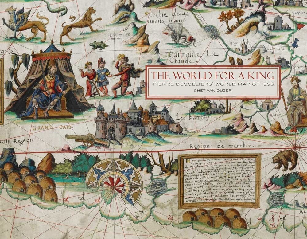
The World for a King on Amazon.com

Chet Van Duzer is an American historian of cartography, specializing in medieval and Renaissance maps. He was born in 1966 and grew up in Northern California, and graduated from UC Berkeley. He is a member of the board of the Lazarus Project at the University of Rochester. Van Duzer has published extensively in the field of cartography, including his recent book "Henricus Martellus's World Map at Yale (c. 1491): Multispectral Imaging, Sources, and Influence". Source: perplexity.ai

Image 6 of 12
e226
i13235
14999x9655px

E226 - Campus inter Bohum et Borystenem - 1635

...

Image 7 of 12
e226
i13895
8122x18084px

Carta Marina

Image 8 of 12
e226
i27898
5016x3715px

Carta Marina LOC

Image 9 of 12
e226
i27899
9666x6505px

1933 Keizo Shimada Japanese Manga Pictorial Map of the World

Image 10 of 12
e226
i35988
4032x3024px

Japanese World Map with Stereotypes - 1932 

Image 11 of 12
e226
i35987
5000x3616px

Ulm Ptolemy - 1482

Wikipedia | raremaps.com | perplexity

One of my favorite maps of all time, the story of this map is the story of Western civilization, which owes a debt to Islam. Ptolemy, in the 2nd century AD, knew and wrote about Europe, Africa and Asia, in a book called Geographia, which included the first system of longitude and latitude, as well as about 8,000 lat-long coordinates for cities. When the Roman Empire fell in the 5th century, Ptolemy’s book made its way to Bagdad and, during the Islamic Golden Age, from roughly 750 to 1250, this book was translated from Latin into Arabic. With the fall of Bagdad and the awakening of the Renaissance, this book made its way to Europe and, in 1482, Ptolemy’s book and this map were created and published in Ulm.


Write a 200-word summary of the map titled the Ulm Ptoley world map of 1482.

The Ulm Ptolemy world map of 1482 is a landmark in cartographic history, notable for being the first printed world map produced north of the Alps and the first to appear in color, with the seas rendered in a vibrant blue. Published by Lienhart Holle in Ulm, this map was based on the manuscript work of Donnus Nicolaus Germanus and engraved by Johannes Schnitzer of Armsheim, whose signature appears on the map—the earliest known example of a signed world map engraving16.

The map follows the Ptolemaic tradition but incorporates some contemporary updates, such as detailed depictions of Scandinavia and Greenland, reflecting the latest geographical knowledge of the time456. However, it omits Portuguese discoveries along the African coast and retains a closed Indian Ocean, linking Asia and Africa with a speculative southern continent12. Surrounding the map are twelve wind heads, each named, adding decorative and symbolic elements16.

Printed from woodblocks rather than copperplates, the map is visually distinctive, with bold, sturdy lines and rich coloring. The Ulm edition also introduced four new regional maps to the atlas, marking a significant evolution from earlier Italian editions. The 1482 Ulm Ptolemy remains highly prized for its artistic quality and historical significance456.

  1. https://www.raremaps.com/gallery/detail/14277/untitled-map-of-the-world-1482-ulm-ptolemy-world-map-ptolemy-holle
  2. https://www.raremaps.com/gallery/detail/8154/untitled-map-of-the-world-1486-ulm-ptolemy-world-map-ptolemy-holle
  3. https://www.raremaps.com/essay/5/the-ulm-ptolemy-of-1482-and-1486
  4. https://gallery.lib.umn.edu/exhibits/show/ptolemy-s-world/tour-of-maps/1482---ulm
  5. https://apps.lib.umn.edu/bell/map/PTO/TOUR/1482u.html
  6. https://www.christies.com/en/lot/lot-5780582
  7. https://collections.lib.uwm.edu/digital/collection/agdm/id/23096/
  8. https://demo.mediainfo.com/item/230
  9. https://www.cabinet.ox.ac.uk/ptolemy-world-map-1482-0
  10. https://www.geographicus.com/P/AntiqueMap/egypt-ptolemy-14

How did Geography by Ptolemy from classical times until the renaissance?

Ptolemy’s Geography (or Geographia) was a transformative work that shaped the understanding and representation of the world from classical antiquity through the Renaissance. Written around 150 AD, it introduced a systematic approach to mapping the world, using mathematical principles and a coordinate system of latitude and longitude based on a prime meridian at the "Fortunate Isles" (Canary Islands)15. Ptolemy’s work synthesized earlier geographic knowledge, notably refining the methods of Marinus of Tyre, and included detailed instructions for mapmaking, a gazetteer with coordinates for thousands of locations, and regional as well as world maps15.

After flourishing in the Roman and Byzantine worlds, Geography faded in Western Europe during the early Middle Ages, as religiously symbolic maps (like T-O maps) dominated5. However, the text was preserved and expanded upon by Islamic scholars, who translated and commented on it, keeping its scientific legacy alive5. The Renaissance saw a revival: Byzantine scholars reintroduced the text to Western Europe, leading to a Latin translation in 1406 by Jacopo d’Angelo15. Printed editions with reconstructed maps appeared from 1477 onward, revolutionizing European cartography by emphasizing empirical observation and mathematical accuracy over medieval symbolism145. Ptolemy’s methods influenced explorers, mapmakers, and the broader development of geographic science well into the modern era35.

  1. https://en.wikipedia.org/wiki/Geography_(Ptolemy)
  2. https://digitalmapsoftheancientworld.com/ancient-maps/ptolemys-map/
  3. https://press.uchicago.edu/ucp/books/book/distributed/P/bo56698759.html
  4. https://www.folger.edu/explore/collection-highlights/ptolemy-edition-of-1513/
  5. https://www.mixplaces.com/ptolemys-geography
  6. https://www.thoughtco.com/ptolemy-biography-1435025
  7. https://www.britannica.com/biography/Ptolemy
  8. https://library.fiveable.me/key-terms/hs-california-history/ptolemys-geography
  9. https://www.nypl.org/events/exhibitions/galleries/explorations/item/5384
  10. https://sterncenter.library.jhu.edu/early-book-collections/ptolemys-geography-in-the-renaissance/

[ 2025-06-01 18:46:28 ]

Image 12 of 12
e226
i36508
27077x19358px
Dots count
0

No dots yet

Dots count
0

No dots yet

Dots count
0

No dots yet

Dots count
0

No dots yet

Dots count
0

No dots yet

Dots count
1
1
emilyyang
(@emilyyang)
Jun 01 2023
0.5
0.31
Dots count
0

No dots yet

Dots count
0

No dots yet

Dots count
0

No dots yet

Dots count
0

No dots yet

Dots count
0

No dots yet

Dots count
0

No dots yet

1

Place a DOT on the image